Saturday, July 16, 2011

Most beautiful place -"Ilam"

Ilam is a municipality and tea-producing town in Nepal. It is in Ilam District which is in hilly Eastern Region of Nepal. It is famous for its natural sceneries and landscapes.
Ilam is a small hilly town with pristine landscapes of sloped tea gardens, thick natural forests, holy sites and unique culure. Ilam offers an excellent getaway from city life for romantic sunrise and sunset, a brisk walk in the tea garden, tranquil picnic and sightseeing spots, short treks along gentle slopes or a trudge into the nearby woods. If spiritual instinct calls there are several holy sites one can visit in and around the area. Thus, Ilam is a much sought after tourist destination for travelers of all kinds. It is also famous all over the world for its special brand Ilam Tea.
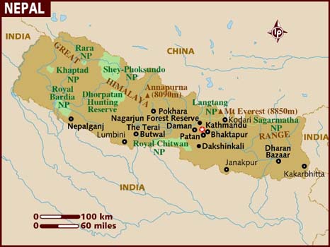
 Ilam Bazaar is in Ilam district Mechi Zone. It is approximately 700 kilometers and 18 hour-drive to east of Kathmandu. Daily bus services ply for Ilam from central Bus Station, Gongabu, in Kathmandu. Buses are also available from the major cities. There are flights from Kathmandu to Biratnagar and Bhadrapur from where Ilam can be driven to via Birtamod.The famous Darjeeling city of India isjust 2-hours drive from Pashupatinagar on the Nepal-India border of Ilam district.

Nepali nationals and Indians can commute by the land to India from Pashupatinagar in Ilam. However, this entry/exit poin is for local use and Indian tourists only. Entry and exit from the eastern point for other travelers is allowed from Kakkarbhitta in Jhapa.
The subtropical climate of Ilam ensures good weather throughout the year. The best time to visit Ilam is between October-December, or from April-February. People from different parts of Nepal visit Maipokhari in Ilam for an annual festival on Kartik Ekadasi which falls in October or November.  Thousands visit Mai Beni during Maghe Sankranti which falls in January.
 The main groups residing in Ilam are Brahimins, Chhetris, and Lepchas. A Lepchas is at initial stage at Antu and is in the process of being extended. Antu Danda offers spectacular sunrise, sunset and views of the Himalayas. From 2,328 meters, Antu overlooks Terai flatlands, terraced hills of cash crops, tea gardens and thick forests of pine trees. On a clear day one can see views as far as Mirik, Kurseong and Darjeeling in the adjoining Indian part. Antu Danda is an hour drive from Pashupatinagar and about 3-hours drive from Ilam Bazaar. Home-stay facilities are available at Antu Danda area.

The beautiful wild life reserve -"Koshi Tappu Wildlife Reserve"


The wildlife reserve and Koshi Barrage lies in the eastern Terai along the east west high way. A very large number of birds are seen along the wide Koshi River and in the grassland and marshes. About 26 species of Ducks are seen in the numerous ponds. Birds found in these areas are Black Ibis, Honey kites, Os preys, Marsh & Pied Harriers, Stork Billed Kingfishers, Black Headed Orioles, Himalayan Ruby Throat, Peregrine Falcon, Patridges, Sand Pipers etc. Over 450 species of birds have been sighted here.
 Koshi Tappu Wildlife Reserve occupies 17,500 ha of the Sapta Koshi River floodplain at the most northeasterly extension of the Gangetic Plain. It ranges in altitude from 75-81 m (Green 1993). The reserve is located between two flood control embankments and is subject to annual flooding. Approximately 70% of the reserve's land area is covered in grasslands (Heinen 1993), although during high flood years a large area of grassland is destroyed and replaced by new alluvial deposits. Typha and Saccharum are major grassland types found here, although patches of Imperata and Phragmites are often seen (Peet et al. 1999a). Medium size phantas interspersed with young Acacia trees are found in sandy islands. Riverine vegetation with Acacia catechu/Dalbergia sissoo forest dominates on the islands and edges of the reserve. Mostly young trees grow inside and on the edges of the reserve within embankments, the old mature trees being swept away by annual floods. 
South of Koshi Tappu Wildlife Reserve lies the Koshi Barrage area. The area is 7 km from north to south and nearly 5 km from east to west. More than 50% of the land area at the barrage is covered by water, and the remaining land area is subject to intensive agriculture. The barrage gates are regulated by the Indian Government according to a 99-year lease agreement between Nepal and India.
 Koshi Tappu is protected as a Ramsar Site for its importance for migrating wildfowl, the first Ramsar Site established in Nepal (Green 1993). In spite of this, the reserve faces severe problems. Koshi wetland habitats are threatened by the large population of subsistence farmers and fishermen living in close proximity to the reserve. Illegal grazing by domestic animals, fodder collection, hunting, illegal fishing, disturbance of nesting and feeding areas, poisoning that not only kills fish, but also birds that feed on fish and aquatic insects, have together resulted in the deterioration and loss of suitable habitats for birds and other wildlife (Anon 1992, Petersson 1998, Giri 1997, 2002). 
 Removal of dead logs and debris deposited in the river from the Reserve is rampant and has a direct effect on fish population. Significant populations of feral cattle and buffalo that are now very wary are adding to the problem of illegal grazing. Heinen (1993) found that the main reason local people disliked the reserve was the frequent damage to crops caused by the Asian Buffalo. A study carried out in 1986-1988 found that people in the area are dependent on the reserve for the collection of grasses that are used in building.
i really feel the joy and happiness after
visiting this place, i think you may should also,what do think about it?

Janakpur Dham of Nepal-"The Regional place''

Dhanushadham is a historical and religious site, its reference dating back to the great Hindu epic Ramayana. It is believed to be the place where fell broken remains of the divine shiva bow that Ram broke to obtain Sita’shand for marriage. A fossilized fragment of the broken piece is still believed to be seen and is worshipped by devotees. 
Nearby is Janakpur, the capital of ancient Mithila culture, and famous as birthplace of Sita believed to be incarnation of Goddess Lakshmi of the Hindu mythology. It is also believed to be the place where lord Ram and Sita met for the first time, fell in love and were married to each other. A temple in janakpurdham known as Janaki Temple dedicated to Sita, is the prime attraction of this region.
Dhanusha offers religious sightseeing, rich Terai flora and fauna, semi-rural charm of the Janakpur suburbs and the colorful art and culture of south Nepal. Janakpur also falls on the holy route of Parikrama carried out by the Hindus as a form of worship in Ayodhya, Kashi and Brij in India as well. 
Dhanushadham is in Dhanusha district and Janakpur zone. Janakpur is approximately 390 kilometers and 10 hour drive from  kathmandu.

The best months to visit Dhanushadham is between October-March. The weather is hot, humid during summers and pleasant during winters, with maximum rain between June-August.Festival celebrated with much pomp and joy are: Ram Navami during Dashain in October, Vivah Panchami that celebrates Ram-Sita union in November, the famous Terai festival of Chhat Parba also in November, Maghe Sankranti in January, and Falgun Purnima in February or March when thousands of devotees carry out Parikrama of Janakpur and nearby sacred sites.
 Janaki Mandir also known as Naulakha Mandir is dedicated to Sita who is also known by the name Janaki. A rare blend of Mughal and Rajput architecture, the temple is the first and only example of its kind in Nepal. The temple has a beautiful garden and an adorned Vivah Mandap or wedding courtyard dedicated to Ram and Sita. The temple is in Janakpur city, the headquarters of Dhanusha district.

Janakpur Dham of Nepal-"The Regional place''

Dhanushadham is a historical and religious site, its reference dating back to the great Hindu epic Ramayana. It is believed to be the place where fell broken remains of the divine shiva bow that Ram broke to obtain Sita hand for marriage. A fossilized fragment of the broken piece is still believed to be seen and is worshipped by devotees.
Nearby is Janakpur, the capital of ancient Mithila culture, and famous as birthplace of Sita believed to be incarnation of Goddess Lakshmi of the Hindu mythology. It is also believed to be the place where lord Ram and Sita met for the first time, fell in love and were married to each other. A temple in janakpurdham known as Janaki Temple dedicated to Sita, is the prime attraction of this region.
                            Dhanusha offers religious sightseeing, rich Terai flora and fauna, semi-rural charm of the Janakpur suburbs and the colorful art and culture of south Nepal. Janakpur also falls on the holy route of Parikrama carried out by the Hindus as a form of worship in Ayodhya, Kashi and Brij in India as well.Festival celebrated with much pomp and joy are: Ram Navami during Dashain in October, Vivah Panchami that celebrates Ram-Sita union in November, the famous Terai festival of Chhat Parba also in November, Maghe Sankranti in January, and Falgun Purnima in February or March when thousands of devotees carry out Parikrama of Janakpur and nearby sacred sites.
 Diverse cultural groups live in the district of Dhanusha. Yadavs, Teli, Brahmins, Kayastha, Tharu, Musahar, Rajput, and Chhetri, are the main inhabitants of these villages. Most are farmers by occupation. The whole region is also considered center of the Maithali culture, therefore Maithali art and culture is predominant in this area.Janaki Mandir also known as Naulakha Mandir is dedicated to Sita who is also known by the name Janaki. A rare blend of Mughal and Rajput architecture, the temple is the first and only example of its kind in Nepal.
 Dhanusha Mandir in Dhanushadham is a historical temple constructed in 1939 A.D. Dhanushadham falls on the resting place of Parikrama route that has special significance to Hindus. It is situated 18 kilometers north east of Janakpurdham and only 10 kilometers from Dharapani on East-West Highway.

Beutiful lumbini in Nepal

 
Lumbini, Nepal, is one of the four most holy places for Buddhists and it is also of great importance to Hindus.
It is situated at the foothills of the Himalayas, in the Terai plains of southern Nepal.
Buddha was born in Lumbini over 2,500 years ago when his mother, Maya Devi was passing through Lumbini on her way to visit her
parents.  When she reached Lumbini, the labour pains started and she had to holdonto the branch of a tree for support as she delivered her child. 
                                       
  Maya Devi was entranced by the beauty and tranquillity of Lumbini, in particular Lumbini's beautiful gardens and wildlife. A ancient temple now exists
Lumbini which is named after Maya Devi.  There are also the remains of a sacred pond, which Maya Devi is believed to have bathed in.
 Although Lumbini became neglected during the years following Buddha's birth and many of the sites were left to go to ruin, Lumbini still retained it's
position as one of Nepal's most sacred sites. A number of key figures in Nepal have left their mark on Lumbrini. Ashoka, the magnanimous Indian Emperor
visited Lambrini in 246 BC.  During his visit to Lambrini, Ashoka left one of his trademark inscribed pillars at the site.  The pillar is approximately six meters
tall.  Half of the pillar is buried, whilst the other half is exposed. The pillar collapsed when it was struck by lightning and further years of neglect
meant that the pillar was only rediscovered during an excavation at the end of the 19th century. 
Many of the sacred sites of Lumbini were destroyed or ruined during the Moghul invasion into Nepal t the end of the 15th century as the monuments were considered
Fortunately however, many have survived sufficiently for a trip to Lumbini during your time in Nepal to be worthwhile. You will certainly benefit from the
tranquillity and the peace in Lumbini. 
In addition to the Sacred Pond and the Maya Devi temple, the other important sites of Lumbini include the Ashokan Pillar (as referred to above  and the Tibetan
and Themravada Viharas.
                                       

Friday, July 15, 2011

Jomsom beauty in Nepal

 Jomsom, also known as Dzongsam or New Fort, is a town located at an altitude of 2800m in Mustang, Nepal. It extends over both the banks of the Kali Gandaki River. Along the banks of Kali Gandaki river there are rocks holy to the Hindus. The soaring peaks of Dhaulagiri and Nilgiri form a backdrop. As the district headquarters, it is primarily an administrative and commercial center with government officials and merchants rubbing shoulders with the local residents of the region, known as Thakalis. A company of the Nepalese Army is stationed here.  
    Jomsom, is important for its strategic position along the popular Around Annapurna (Circuit) Trek route. It is also the starting point for many interesting treks like the Kagbeni, Marpha, Muktinath and Mustang treks. The Jomsom Trek is known for splendid mountain views and some of the best trekking hotels are found on this route.
                          in my opinion jomsom is the one of the best place which has the natural beauty and all the attraction which can attracts everybody.             
        you can also see the natural beauty of jomsom and to see
you can follow the address given below:-
seen of natural in Jomsom       .and  you will feel such i felt after viewing it.

Natural beauty of Pokhara

Nepal's most beautiful natural valley, which is also the most popular tourist destination. The Annapurna, Machhapuchere (Fishtail) and uncountable Mountains always stand high welcoming every visitor with a smile.

Pokhara is situated in the northwestern corner of the Pokhara Valley, which is a widening of the Seti Gandaki valley. The Seti River and its tributaries have dug impressive canyons into the valley floor, which are only visible from higher viewpoints or from the air. To the east of Pokhara is the municipality of Lekhnath, another town in the valley.
Pokhara is a remarkable place of natural beauty. Situated at an altitude of 827m from the sea level and 200km west of Kathmandu valley, the city is known as a center of adventure.The serenity of lakes and the magnificence of the Himalayas rising behind them create an ambience of peace and magic. So today the city has not only become the starting point for most popular trekking and rafting destinations but also a place to relax and enjoy the beauty of nature.                        
flying in the sky of pokhara
Mirror of mountain in the lake
Really the most beautiful place i have ever visited in my life . Totally heaven in Nepal. 


for the lover of nature should be once time to spend here the real heaven.

Tuesday, July 12, 2011

Adventure of Mt. Everest

Everest’s daunting summit soars so high that trekking to its base camp (17,590') is still an adventure of the highest sort. Join National Geographic on a 14-day Himalayan trek to Everest’s Southern Face Base Camp through some of the world’s most spectacular mountain scenery. Spend two days discovering the historic treasures of Kathmandu. Stay in villages set against soaring, jagged pinnacles; get to know the unique culture of the Sherpa; and walk trails lined with Mani stones, engraved with Tibetan Buddhist prayers. Discover remote mountain monasteries and learn about the Sherpa’ spiritual perspective on the mountains they call home.


 -Trek to the foot of breathtaking Everest, the world’s highest mountain.
 -Set out on challenging hikes to Kala Pattar (18,192'), Nangkartshang Peak (16,672'). and Everest Base      Camp (17,590').

-Explore Sherpa villages and the ancient Thami and Tengboche monasteries.

-Visit a school established by Sir Edmund Hillary in the mountain village of Khumjung. 


Saturday, July 9, 2011

Peak of the world


Mount Everest ( Sagarmatha) is the world's highest mountain at 8,848 meters (29,029 ft) above sea level.Everest is in the Mahalangur section of the H imalaya on the Nepal-China (Tibet) border. Its massif includes neighboring peaks Lhotse(8516m), Nuptse (7855m), and Changtse (7580m).
In 1856, the great trignometric survey of British India established the first published height of Everest, then known as Peak XV, at 29,002 ft (8,840 m). In 1865, Everest was given its official English name by the real geographical society upon recommendation of Andrew Waugh, the british surveyor of india at the time, who named it after his predecessor in the post, and former chief, Sir george everest. Chomolungma had been in common use by Tibetans for centuries, but Waugh was unable to propose an established local name because Nepal and tibet were closed to foreigners.
The highest mountain in the world attracts many well-experienced mountaineers as well as novice climbers who are willing to pay substantial sums to professional mountain guides to complete a successful climb. The mountain, while not posing substantial technical climbing difficulty on the standard route (other eight thousanders such as K2 or Nanga parbat are much more difficult), still has many inherent dangers such as altitude sickness, weather, and wind.

By the end of the 2008 climbing season, there had been 4,102 ascents to the summit by about 2,700 individuals. Climbers are a significant source of tourist revenue for Nepal, whose government also requires all prospective climbers to obtain an expensive permit, costing up to US$25,000 per person.By the end of 2009 Everest had claimed 216 lives, including eight who perished during a 1996 storm high in the mountain Conditions are so difficult in the death zone—altitudes higher than 8,000 metres (26,000 ft)—that most corpses have been left where they fell. Some of them are visible from standard climbing routes.

Thursday, July 7, 2011

Introduction to Nepal


Nepal is one of the richest countries in the world in terms of bio-diversity due to its unique geographical position and altitude variation. The elevation of the country ranges from 60 meters above sea level to the highest point on earth, Mt. Everest at 8,848 meters, all within a distance of 150 kilometers resulting in climatic conditions from Sub-tropical to Arctic .
 
Nepal, home to Mount Everest, is dominated by the world's most imposing mountains. Although the country is relatively small (147,181 square kilometers), 80 percent of its territory is occupied by the dramatic peaks of the Himalayas.Nepal was closed to foreign visitors until1951, a situation which contributed greatly to its mystique in the west. This small, hospitable country has since become an exceptionally popular destination for travelers, whether they are in search of climbing challenges or spiritual enlightenment.
              Enchantment is everywhere in Nepal; be it in the cool and invigorating shade of the high mountains, or on terraced farmlands carved like stairways out of hill ridges, or still across waterfalls, creeks, rushing mountain rivers amidst gorges, valleys and forests teeming with a cornucopia of flora and fauna.  There are lakes amidst breathtaking settings, strong-current rivers for rafting, Wildlife Safaris, the tallest mountains to climb, trekking across vales and dales, and, above all, warm, friendly, welcoming people. In this respect, Nepal becomes a perfect holiday destination for tourists, trekkers, mountaineers, writers, honeymooners, lovers, retired people and people interested in research.